
Tropical Depression Kiyapo is the Philippines’ 11th tropical cyclone for 2026, and the fourth for July alone.
MANILA, Philippines – A low pressure area within the Philippine Area of Responsibility (PAR) intensified into a tropical depression at 8 pm on Wednesday, July 22.
It was given a local name What ifbeing the 11th typhoon in the country for the year 2026. It is also the fourth tropical typhoon in July alone.
As of 10 pm on Wednesday, Kiyapo was located 1,080 kilometers east of southeast Luzon, moving northwest at 25 kilometers per hour (km/h).
A tropical depression has sustained winds of 45 km/h and gustiness up to 55 km/h.
The Philippine Atmospheric, Geophysical and Astronomical Services Administration (PAGASA) said Kiyapo may approach or make landfall in Babuyan Islands in Cagayan province by Friday evening, July 24. Landslides in Cagayan are also not ruled out.
As it approaches Cagayan, Kiyapo may intensify into a tropical storm by Friday. It may even reach severe tropical storm status before it makes landfall.
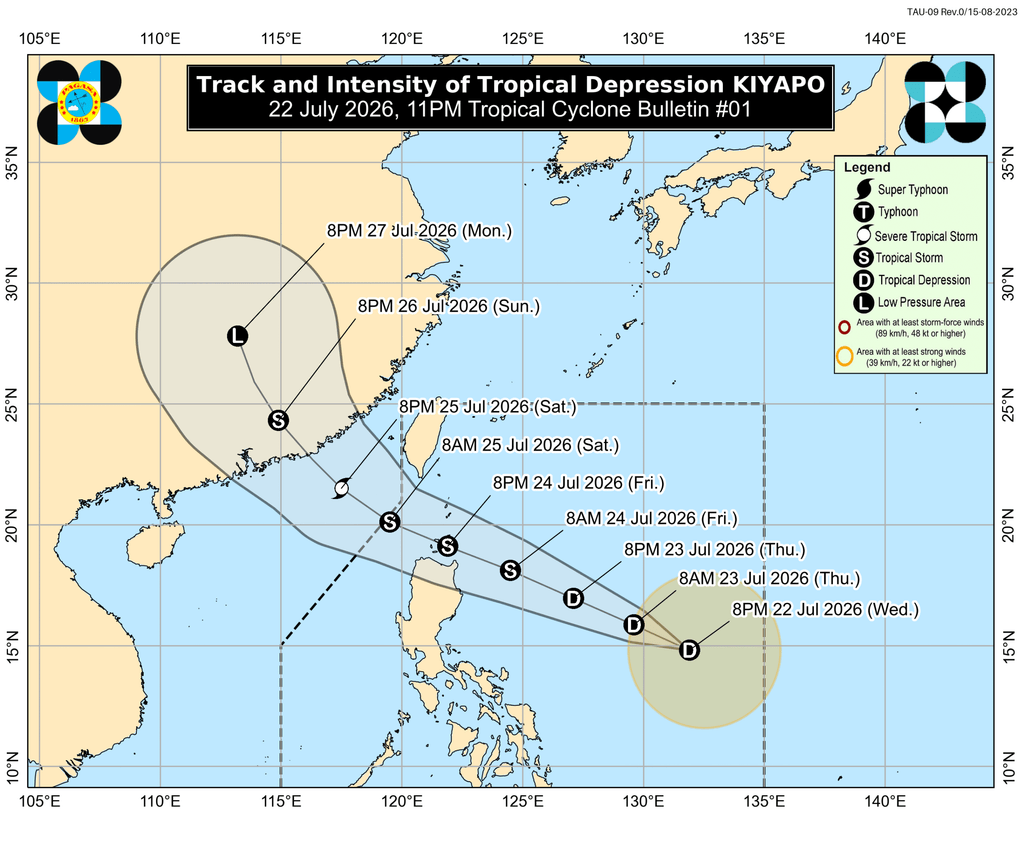
In PAGASA’s previous statement of Kiyapo issued at 11 pm on Wednesday, it already appeared Wave number 1 for parts of Cagayan and Isabela, giving them 36 hours to prepare for strong winds:
- the eastern part of mainland Cagayan (Santa Ana, Gonzaga, Lallo, Gattaran, Baggao, Peñablanca, Santa Teresita, Buguey)
- eastern part of Isabela (Isabela, San Pablo, Cabagan, Tumauini, Ilagan City, Divilacan, Palanan, San Mariano, Dinapigue)
The highest tropical cyclone strength signal from Kiyapo could be Wave Number 2 or 3.
PAGASA added that southwest monsoon or southwest and the periphery or outer belt of the tropical cyclone will bring strong winds to the following areas:
Thursday, July 23
- more than Mindanao, Siquijor, Bohol, Southern Leyte
Friday, July 24
The weather bureau also warned Northern Luzon to prepare for moderate to heavy rain from Kiyapo in the coming days. Here is the latest rainfall outlook for the tropical cyclone, issued at 11pm on Wednesday:
Thursday evening, July 23, to Friday evening, July 24
- Heavy to heavy rainfall (100-200 mm): Cagayan
- Moderate to heavy rainfall (50-100 mm): Batanes, Isabela, Apayao, Kalinga, Abra, Ilocos Norte
Friday evening, July 24, to Saturday evening, July 25
- Heavy to heavy rainfall (100-200 mm): Cagayan, Apayao, Abra, Ilocos Norte, Ilocos Sur
- Moderate to heavy rainfall (50-100 mm): Batanes, Isabela, Kalinga, Mountain Region, Ifugao, Benguet, La Union
Apart from Kiyapo, the southwest monsoon will be bringing moderate to heavy rain, too.
Wednesday evening, July 22, to Thursday evening, July 23
- Moderate to heavy rainfall (50-100 mm): Zamboanga del Norte, Zamboanga Sibugay, Zamboanga del Sur, Lanao del Norte, Lanao del Sur, Maguindanao del Norte, Sultan Kudarat, Sarangani
Thursday evening, July 23, to Friday evening, July 24
- Moderate to heavy rainfall (50-100 mm): Kale, Negros Occidental, Negros Occidental, Zamboanga Sibugay, Zamboanga South, Lanao North, Lanao South, Maguindanao North
Friday evening, July 24, to Saturday evening, July 25
- Moderate to heavy rainfall (50-100 mm): Occidental Mindoro, Kale, Iloilo, Guimaras, Negros Occidental
All areas that will be affected by Kiyapo and the southwest monsoon should watch for floods and landslides.
In addition, in the next 24 hours, the conditions in some sea boards will be dangerous for small vessels.
To rough seas (small ships should not go to sea)
- Southeast Davao Oriental sea – waves up to 3 meters high
Moderate to rough seas (small vessels should take precautions or avoid sailing, if possible)
- The southern and remaining eastern seaboard of Davao Oriental – waves up to 2.5 meters high
- Seas of Davao Occidental and Surigao del Sur – waves up to 2 meters high
After its possible landfall in Cagayan, Kiyapo may exit the Luzon Strait and finally exit PAR by Saturday morning or afternoon, July 25. – Rappler.com